
There is an earlier post i made today that's more about my life, that you should probably read if you haven't.
Go back and read that post!
For my non edmontonian friends, I thought I'd give you the benifiet of the doubt, and give you a little tour of my city.
Here's Edmonton; part 1.
look up some pictures on google images, if you're so inclined.

A view of downtown coming over the "low level bridge"

a view of the northern part of downtown from one of the buildings down town

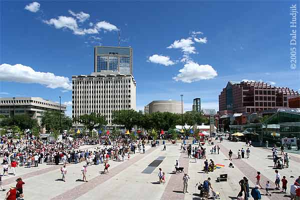
a good view of down town from the south side of the north saskatchewan river, probably taken from the mutart conservatory. The road there is 98th ave, James MacDonald Bridge

a good distance picture of most of downtown

university train station, our "LRT" system - lightweight rapid transit

This would be somewhere inside the "northlands agricom" building, at a car show, note the steeda car.

whye (82nd) avenue, sometime during what looks like around christmas time. This street has been historically preserved, and is lined with bars and trendy shops.

The start of jasper ave where 82nd street curves around at the river and becomes Jasper (100th) avenue. This is pretty much the main vein for cruising downtown.

The high level bridge, seen here, with the "great divide" waterfall turned on. The bridge is absolutely huge, this photo does not do it justice. It connects north central and south central edmonton together one way by 109th street.

an areal view of the university of alberta campus. The picture runs south to north. Closest to you is the U of A hospital, middle left is the butterdome or "pavilion" that houses the running track and fitness facilities.

another view of campus, this time from the east. The yellow building, once again, is the butterdome. The low, long building in the middle right is hub mall, which is actually a mall and a residence. The road on the bottom right is traffic coming up from the high level bridge on 109th street. The left/middle buildings there are where whyte (82nd) ave starts.

edmonton legislature building (as edmonton is the capital of alberta, the provincial government resides (not lives but works) here. The long fountain in front actually doubles as a wading pool on hot days, and the public is allowed to jump right in.

Edmonton city hall. The wet part you see in front of it is either a wading pool/fountain in the summer, or a skating rink in the winter.

a good picture of city hall on a warm night with the wading pool fountains on
sir winston churchill square has the city hall on the north, edmonton city center mall on the west, the edmonton art gallery on the east, and the stanley a. miller library on the south.

west edmonton mall from the outside. The structure houses four fases and thousands of stores and attractions, including a hotel and conference center, a skating rink, a wave pool with water slides, an amusement park with roller coaster, two movie theaters (including one imax theater) and a replica of the santa maria in the middle of the mall.

The inside of west edmonton mall's world water park. The only mall bigger was built by the same owners, the mall of america in minnesota.

This is Rexall Place, formerly known as the "northlands coliseum" as seen in the winter after heavy snow fall from the parking lot, across the pedestrian bridge that crosses 118th avenue. This is of course, the home of our NHL team the Edmonton Oilers.

A view from inside Rexall Place, not much different than any other indoor NHL or NBA arena, except built in 1974, the coliseum is actually considered to be aging and in need of replacement

This is an areal view of Commonwealth Stadium, initially built for the 1978 Commonwealth games, and thereafter served as home to our CFL's Edmonton Eskimos. The picture here was taken about two years ago for FIFA's u19 world cup, obviously during ceremony time. The stadium is one of the few stadiums in Canada that would be able to support, say, an NFL team. Seating capacity is somewhere in the range of 65,000. It's not unlikely for us to get 55,000+ out to Eskimo games, which would make us the only city in canada that has enough football attendence to actually warrant an NFL team. But too many canadians are stuck to the CFL for us to ever see that happen.

some stock footage of the eskimos in action, looks like we were playing the hamilton tiger cats. Yes, we do look like the green bay packers, however, it's more likely that they look like us. The green and gold colors of the eskimos actually dates back to 1908, when the university of alberta was established and took those colors. It was rumored that some time after 1910 (the CFL has been around for a LONG time) the eskimos had their equipment stolen. They borrowed the U of A Golden Bear's equipment, and ever since have had the green and gold uniforms.

Edmonton oilers on ice, against one of the dallas stars.

A good ariel view of what most of the newer neighbourhoods in the city look like.

This areal view of the city was taken sometime circa '77. Since then the city has grown to more than three times the size, with most of the growth being within the last 10 years.

traffic going into down town from south/central edmonton. South Central is not the negative type of connotation that south central LA has. On the contrary, it is almost the opposite. South Central Edmonton is the perfect place, with expensive land values, a great view of downtown, close to the university campus, and close to several main traffic veins to get anywhere else in the city.

So much for the copyright. An aerial view taken in summer of '05 of north east edmonton. That main road is manning freeway. Due to the quick construction and huge housing market, this has almost filled up all with houses. The man made lake on the right side of manning freeway, the road just above it, that's 153rd avenue. Follow that line to the "M" in image, where another manmade lake is, and that's the area where my house is situated. The man made lakes on this side of the city are built because the area is a natural wetland. All the districts are slanted towards these lakes that drain into the storm sewer system if they get to high (which empties out into the river) and keeps the area nice and dry, keeps houses from being flooded, and still provides natural wetland to geese and other migrating animals that used to use the area.

Here's what you get with the south side of the city. The infamous high speed whitemud drive (a freeway) and all the accidents that go along with that. This is the south side's main east/west vein. On the north side of the river, that would be the yellowhead.

Facing north on 82nd street, the exit to yellowhead trail.
There's your tour of edmonton PT 1...
Go back and read that post!
For my non edmontonian friends, I thought I'd give you the benifiet of the doubt, and give you a little tour of my city.
Here's Edmonton; part 1.
look up some pictures on google images, if you're so inclined.
A view of downtown coming over the "low level bridge"
a view of the northern part of downtown from one of the buildings down town
a good view of down town from the south side of the north saskatchewan river, probably taken from the mutart conservatory. The road there is 98th ave, James MacDonald Bridge
a good distance picture of most of downtown
university train station, our "LRT" system - lightweight rapid transit
This would be somewhere inside the "northlands agricom" building, at a car show, note the steeda car.
whye (82nd) avenue, sometime during what looks like around christmas time. This street has been historically preserved, and is lined with bars and trendy shops.
The start of jasper ave where 82nd street curves around at the river and becomes Jasper (100th) avenue. This is pretty much the main vein for cruising downtown.
The high level bridge, seen here, with the "great divide" waterfall turned on. The bridge is absolutely huge, this photo does not do it justice. It connects north central and south central edmonton together one way by 109th street.
an areal view of the university of alberta campus. The picture runs south to north. Closest to you is the U of A hospital, middle left is the butterdome or "pavilion" that houses the running track and fitness facilities.
another view of campus, this time from the east. The yellow building, once again, is the butterdome. The low, long building in the middle right is hub mall, which is actually a mall and a residence. The road on the bottom right is traffic coming up from the high level bridge on 109th street. The left/middle buildings there are where whyte (82nd) ave starts.
edmonton legislature building (as edmonton is the capital of alberta, the provincial government resides (not lives but works) here. The long fountain in front actually doubles as a wading pool on hot days, and the public is allowed to jump right in.
Edmonton city hall. The wet part you see in front of it is either a wading pool/fountain in the summer, or a skating rink in the winter.
a good picture of city hall on a warm night with the wading pool fountains on
sir winston churchill square has the city hall on the north, edmonton city center mall on the west, the edmonton art gallery on the east, and the stanley a. miller library on the south.
west edmonton mall from the outside. The structure houses four fases and thousands of stores and attractions, including a hotel and conference center, a skating rink, a wave pool with water slides, an amusement park with roller coaster, two movie theaters (including one imax theater) and a replica of the santa maria in the middle of the mall.
The inside of west edmonton mall's world water park. The only mall bigger was built by the same owners, the mall of america in minnesota.
This is Rexall Place, formerly known as the "northlands coliseum" as seen in the winter after heavy snow fall from the parking lot, across the pedestrian bridge that crosses 118th avenue. This is of course, the home of our NHL team the Edmonton Oilers.
A view from inside Rexall Place, not much different than any other indoor NHL or NBA arena, except built in 1974, the coliseum is actually considered to be aging and in need of replacement
This is an areal view of Commonwealth Stadium, initially built for the 1978 Commonwealth games, and thereafter served as home to our CFL's Edmonton Eskimos. The picture here was taken about two years ago for FIFA's u19 world cup, obviously during ceremony time. The stadium is one of the few stadiums in Canada that would be able to support, say, an NFL team. Seating capacity is somewhere in the range of 65,000. It's not unlikely for us to get 55,000+ out to Eskimo games, which would make us the only city in canada that has enough football attendence to actually warrant an NFL team. But too many canadians are stuck to the CFL for us to ever see that happen.
some stock footage of the eskimos in action, looks like we were playing the hamilton tiger cats. Yes, we do look like the green bay packers, however, it's more likely that they look like us. The green and gold colors of the eskimos actually dates back to 1908, when the university of alberta was established and took those colors. It was rumored that some time after 1910 (the CFL has been around for a LONG time) the eskimos had their equipment stolen. They borrowed the U of A Golden Bear's equipment, and ever since have had the green and gold uniforms.
Edmonton oilers on ice, against one of the dallas stars.
A good ariel view of what most of the newer neighbourhoods in the city look like.
This areal view of the city was taken sometime circa '77. Since then the city has grown to more than three times the size, with most of the growth being within the last 10 years.
traffic going into down town from south/central edmonton. South Central is not the negative type of connotation that south central LA has. On the contrary, it is almost the opposite. South Central Edmonton is the perfect place, with expensive land values, a great view of downtown, close to the university campus, and close to several main traffic veins to get anywhere else in the city.
So much for the copyright. An aerial view taken in summer of '05 of north east edmonton. That main road is manning freeway. Due to the quick construction and huge housing market, this has almost filled up all with houses. The man made lake on the right side of manning freeway, the road just above it, that's 153rd avenue. Follow that line to the "M" in image, where another manmade lake is, and that's the area where my house is situated. The man made lakes on this side of the city are built because the area is a natural wetland. All the districts are slanted towards these lakes that drain into the storm sewer system if they get to high (which empties out into the river) and keeps the area nice and dry, keeps houses from being flooded, and still provides natural wetland to geese and other migrating animals that used to use the area.
Here's what you get with the south side of the city. The infamous high speed whitemud drive (a freeway) and all the accidents that go along with that. This is the south side's main east/west vein. On the north side of the river, that would be the yellowhead.
Facing north on 82nd street, the exit to yellowhead trail.
There's your tour of edmonton PT 1...
VIEW 5 of 5 COMMENTS
xoxoxoxox